An interesting article in the Guardian, Cities and their psychology: how neuroscience affects urban planning delves into the connection between space and behavior, and more specifically, ways of using technological advances to study and understand (and experiment) with urban spaces.
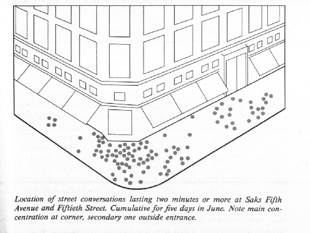
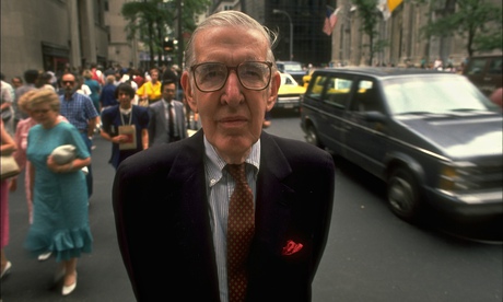
Who better to invoke with this discussion than William H. Whyte, the nerd’s nerd of urbanism research whose books have influenced designers and planners for decades. By using direct observation methods, and as showcased in his writings and films, video of these spaces, he was able to provide specific research, with a direct connection to practice. “Whyte’s research programme, conducted with stopwatches, time-lapse videography, and lots of simple paper charts, was a spectacular success. Based on his findings, he made a series of simple and easily implemented recommendations that the city soon codified into its municipal construction codes.”
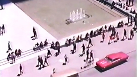 It’s interesting with the technology and ubiquity of video in our lives that there aren’t more modern adaptations of Whyte’s work (although Jan Gehl is probably most visible in this realm). As mentioned, “Whyte’s epiphany was that the way to answer important questions about how to build a commodious and psychologically healthy city lay in careful observation, collection of data and the creative ability to lay aside preconceptions and view a streetscape with a “beginner mind”.
“What has changed dramatically is the set of tools that are available to those who would understand the detailed workings of the urban realm. Now we can go well beyond simple observations of the overt behaviour of city dwellers. We can look inside the bodies and minds of those who inhabit urban spaces. We can measure their gaze, their beating hearts, and the state of their autonomic nervous systems as they react to arousing and stressful events.
The use of physical data rather than speculation is key, and with GPS tracking, sophisticated modeling, portable biofeedback, video, audio and spatial imaging, 3D scanning and other data-driven urban solutions seeming all the rage, through universities and large corporations and focus on urbanization. Tie this to 3D GIS and simulations of city spaces or districts, and it would allow us to develop some pretty sophisticated models of actual behavior and test virtual spaces and conditions. Using Whyte’s baseline methodology with an infusion of technology, we could provide amazing insights on space configuration, wayfinding, urban form, public health, security, and much more. As Colin Ellard mentions in the artcle:
“We also need theory and experiment. For a truly scientific approach to the problem of the city, we need to be able to test hypotheses, and compare alternative urban realities. But how can we do this when our subject matter consists of vast constructions of concrete, glass and metal? We can’t tear down and rearrange city blocks to see what works. In tandem with our arsenal of tools for measurements, we need a way to build hypothetical city spaces. How do we develop an experimental science of urban design?”
His example from folks at research laboratory for immersive virtual environments (Relive) at the University of Waterloo provide examples of new technologies in use. “Participants are placed into highly immersive simulations of city spaces using sophisticated head-mounted displays and precise motion tracking. They are able to walk freely through photo-realistic simulations of urban spaces that are replete with depth, colour, and motion.” The full video here shows some quick renders of a potential study, using immersive technology (Virtual Reality) people can interact with in simulation of a range of environments. One example shows a somewhat monotonous cityscape/street pattern.
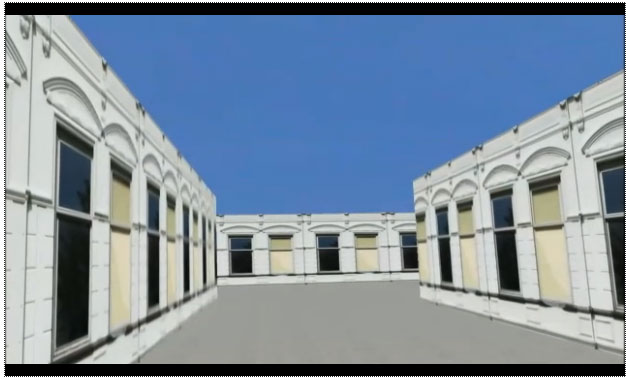
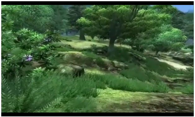
Or a vegetated forest area, both of which have sort of a video-game quality of First-Person Shooters or the ethereal wanderings of the old Myst series, but could also allow for rapid prototyping of parks, open spaces, nature trails, and urban plazas. As mentioned this sort of 3D visualization isn’t new, but perhaps its use in urban space analysis is a new avenue for technologies.
“What is new is the capability and will to explore our reactions to such simulations at a fine-grained level of analysis using sophisticated methods of data collection and analysis. Using such methods, we can explore the behaviour of a visitor to a virtual urban setting whose design, because it is built only of pixels, is entirely under our control and can be arranged and rearranged with a few keystrokes on a computer.
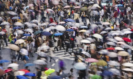
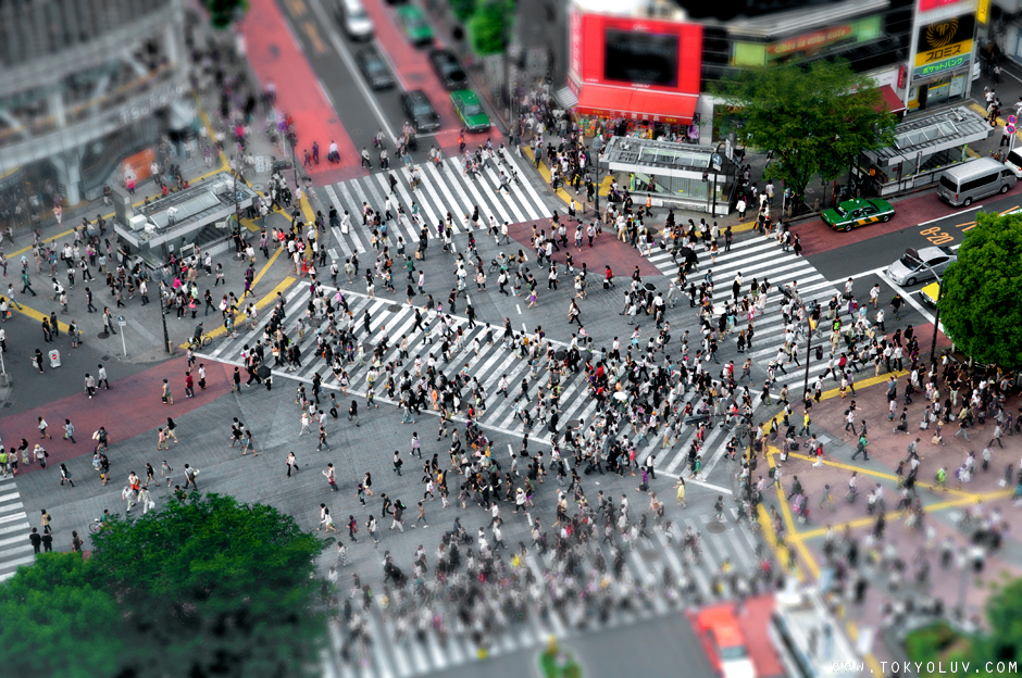
There’s also the ability to simulate already existing real world spaces, such as Tokyo’s Shibuya crossing (below), “one of the busiest and most chaotic pedestrian junctions in the world.” The combination of real space in an experimental setting allows us to control conditions and focus on specific brain/space interactions.
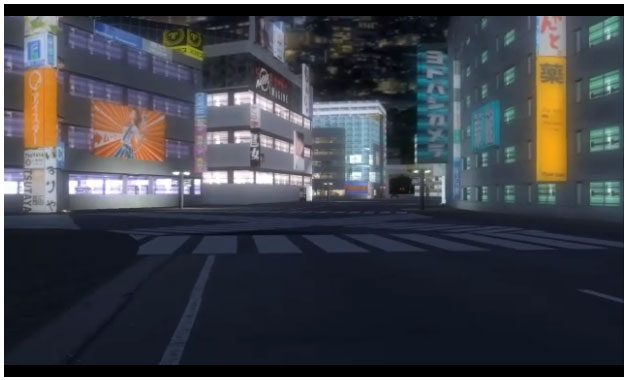
The question of course, is, how closely the data or simulation need to match the real conditions in order to get good feedback from users? But does the rendering of a barren, depopulated Shibuya station really simulate the conditions of this crowded shopping street.
How much wayfining is the physical environmental cues, versus going with the flow of the other pedestrians, being carried along with the masses of urbanity at work. I’m curious if these videos do have a sort of interactive quality (activated with traffic, pedestrians, bicycles, sounds (or even smell and tactile jostling) – and whether some of the aforementioned video- game technology could be applied to urbanism.
Either way, there are a lot of new options, using tried and true techniques of observation, augmented with technology, to provide data on existing spaces, prototype and test new spaces or changes, and to increase our understanding of how to design cities for multiple uses with lots of density. The prospects are exciting.