
I’m happy to be able to share some information on Geodesign from mapping and visualization rock-star Nadia Amoroso. I’ve really enjoyed following her work over the years, and did a thorough exploration of her amazing book The Exposed City: Mapping the Urban Invisibles, back in 2010 (here) and also posted about her work on Data Appeal, a mapping and visualization software tool for making map landscapes in 2011. On my list is to check out her most recent book, Representing Landscapes: Digital, (2015 – Foreword by James Corner) which looks at the cutting edge visual techniques for graphic communication focused specifically on landscape architecture.
Nadia is still hard at work in the mapping and visualization realms – and let me know of some of the work she’s been doing around Geodesign, particularly employing some new digital mapping tools that greater expand this potential. The following post includes a good overview of Geodesign and it’s potential to application in Urban Design and Landscape Architecture contexts. Enjoy!
Geodesign Concept and its Solution Platform for Urban Design and Landscape Architecture
GIS (Geographic Information Systems) is important part of the urban planning and urban design process. GIS has often been associated with science, and not so much on design. Geodesign offers to shake up the notion of GIS. Geodesign provides a design framework and supporting technology for design professionals to leverage geographic information, resulting in designs that more closely follow site and natural systems. [1]
Geodesign is a new way of thinking about the design process, utilizing site data with software such as a GIS (Geographic Information System) to create urban or landscape designs. The Wikipedia’s entry on Geodesign states that ” Geodesign is a set of techniques and enabling technologies for planning built and natural environments in an integrated process, including project conceptualization, analysis, design specification, stakeholder participation and collaboration, design creation, simulation, and evaluation (among other stages). “
Michael Flaxman, former MIT Professor and CEO of Geodesign Technologies, states that “Geodesign is a design and planning method which tightly couples the creation of design proposals with impact simulations informed by geographic contexts.” [2]
Professor Carl Steinitz, Professor of Landscape Architecture and Planning, Emeritus, brought to the limelight the geodesign framework for landscape architects and designers of the built environment, by posing a series of fundamental questions that as designers of the built environment, should think about and address. Refer to the “Geodesign Framework- by Carl Steinitz” for the summary of questions.
ESRI Inc, (the global mapping and GIS company, based in Redlands California), has created a geodesign solution platform (suite of software) that is specifically tailored for the landscape architecture and urban design industries, in order to make strategic urban designs and landscape plans.
Jack Dangermond, the founder and President of Esri, studied landscape architecture at Harvard’s GSD. He has tapped into his landscape architecture roots and is revolutionizing the concept of geodesign for landscape architecture, architecture, planning and urban design fields. Dangermond claims that, “Geodesign is about integrating geographic knowledge with the spatial design process…..design with nature, or geodesign, is our next evolutionary step.”
Esri now hosts an annual Geodesign Summit where landscape architects, architects, academics, urban and transportation planners, and leading though leaders in the industry come together to learn and share their experiences on how the geodesign technology solution platform is being used to make and create smarter cities and sustainable landscapes.
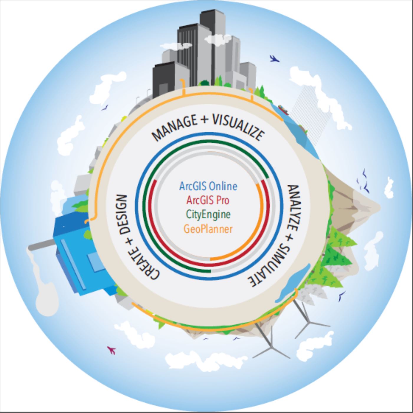
Technology wise, think of CAD, BIM, GIS all in one. Esri offers a suite of software from 2D mapping to 3D modeling as part of the Geodesign solutions, which combines sketching and modeling tools with the power of data, GIS and high quality renderings. The Geodesign Platform includes mainly the following suite of applications:
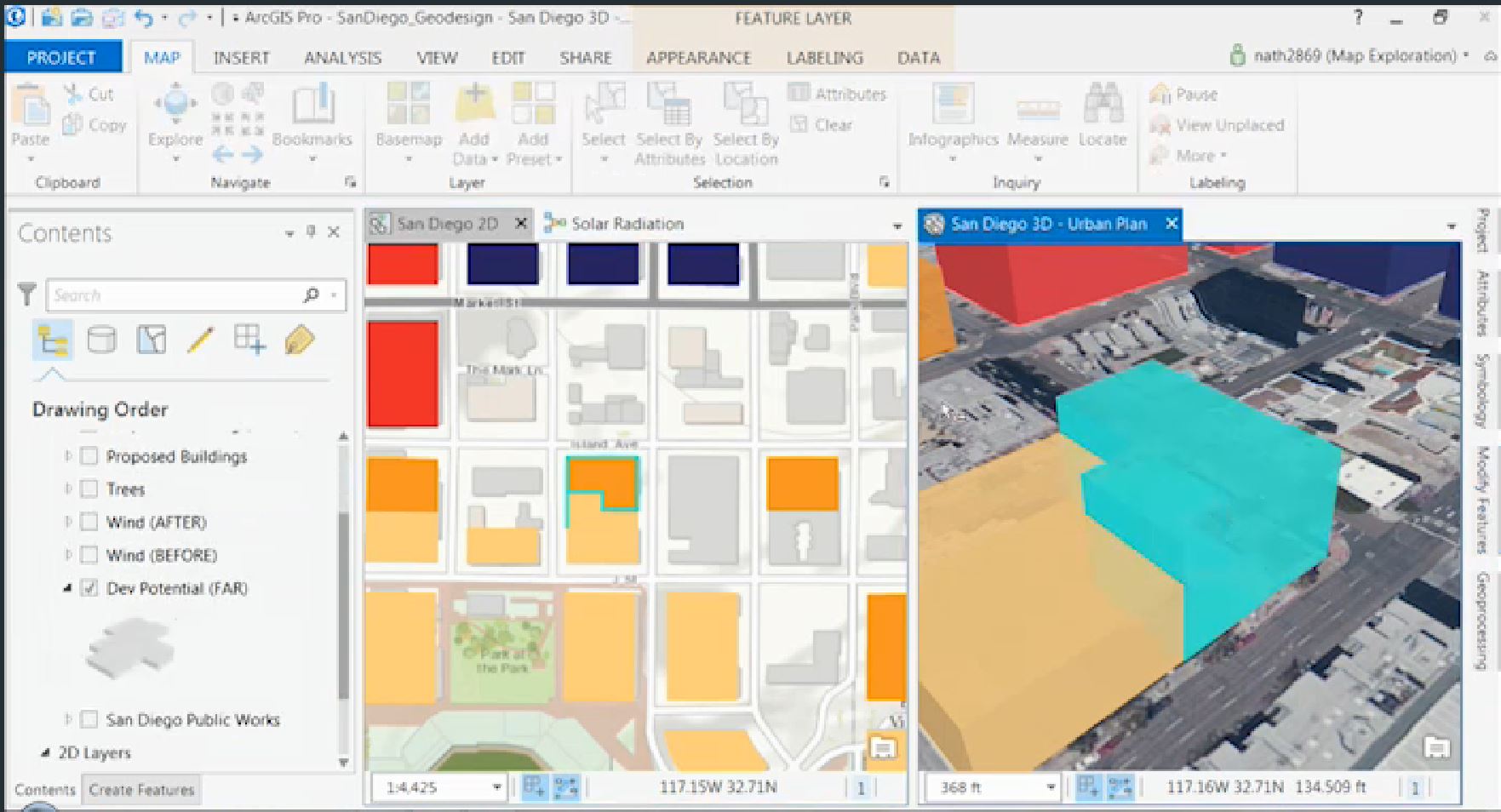
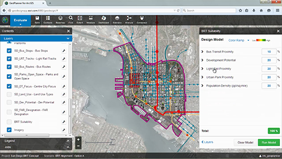
- GeoPlanner for ArcGIS, which is a web-based, easy to use sketching and mapping tool to design scenarios. It leverages geo-based dataand supports all the steps of land-based planning and urban design. This includes sketching and designing scenarios (design alternatives), understanding the impact of your designs, perform site and spatial analysis and compare alternative designs.
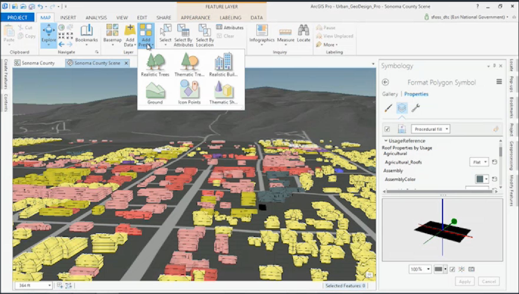
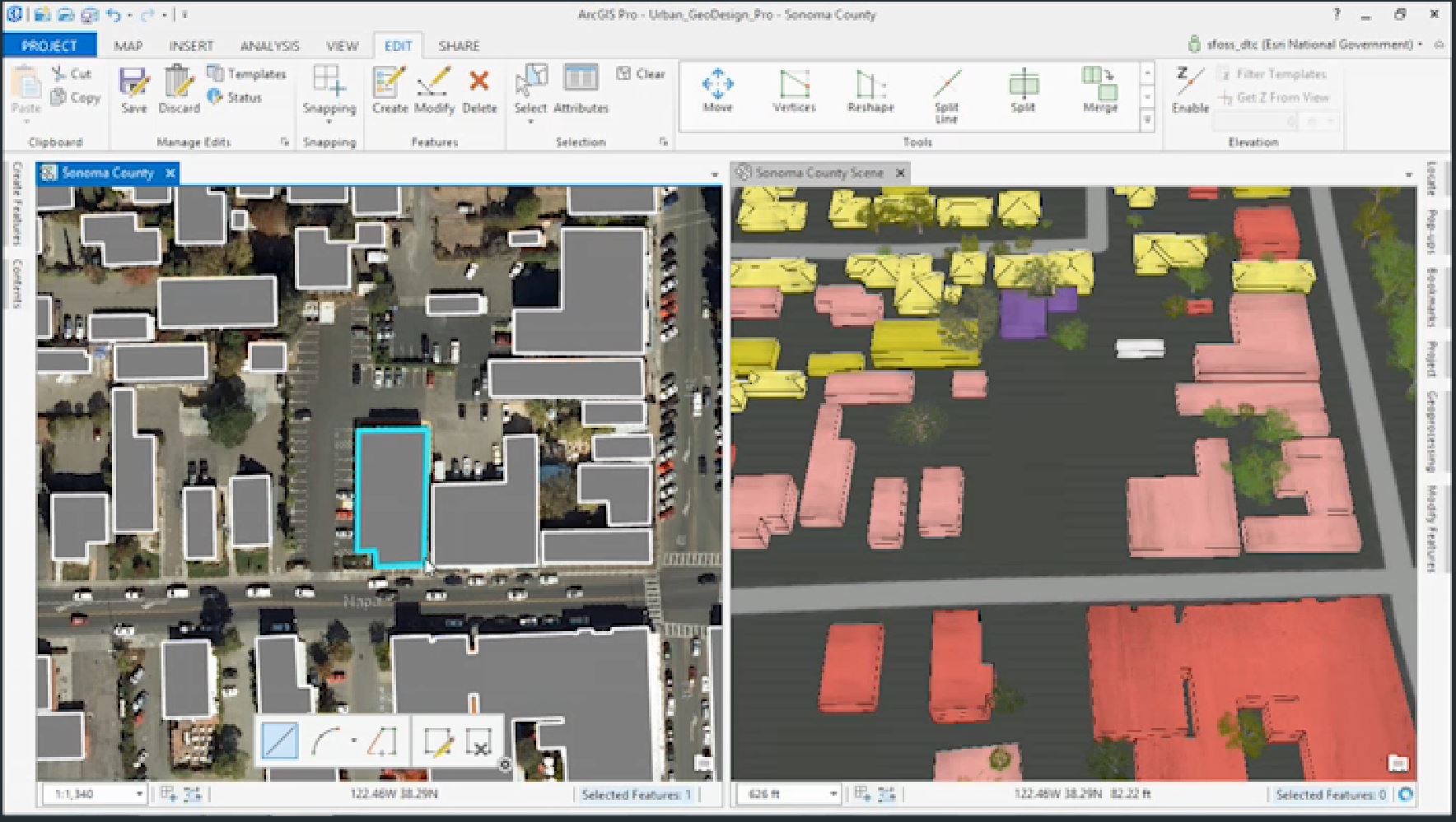
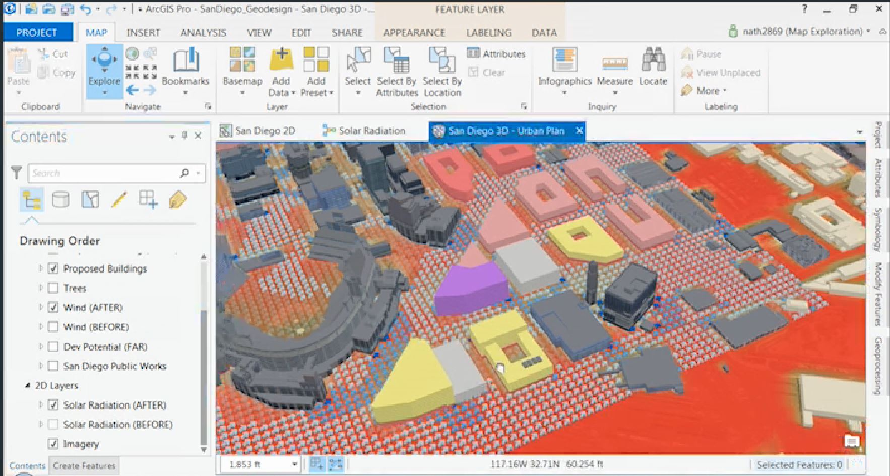
- ArcGIS Pro which is a robust desktop application which render and process data faster than ever. The software allows you to design and edit your concepts in 2D and 3D with multiple view ports. You can perform 3d site analysis like wind analysis, shade/ shadow analysis, circulation patterns, density, view-shed analysis. Designers can add realistic trees, buildings and infrastructures quickly.
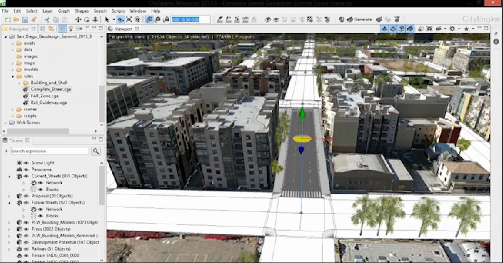
- CityEngine which is a 3D modeling software which leverages parametric modeling and geo-based data to create evidence-based city and landscape designs. CityEngine creates high quality renderings. CityEngine allows you to import your urban design proposals within existing built urban context in CityEngine. Using parametric and rule procedures, the landscape architect can create, change and test mass modeling to comply with zoning regulations; test shadow area; create detailed streetscapes and create quality public realm It offers intuitive and effective tools for façade and landscape texturing, adding landscape elements and various tree species. CityEngine provides perspective correction to capture the right views. CityEngine is integrated with ArcGIS.
All these tools provide real-time feedback on your changing design concepts.
Geodesign combines site and nature “with design by providing designers with robust tools that support rapid evaluation of design alternatives against the impacts of those designs. Geodesign infuses design with a blend of science- and value-based information to help designers, planners, and stakeholders make better-informed decisions….[the geodesign platform] offers geospatial modeling, impact simulations, and real-time feedback to facilitate holistic designs and smart decisions.”[3]
The Esri’s Geodesign Platform is a critical toolkit for urban design and landscape architecture, as a means to make smart design decisions.
Further Reading:
- Esri subject matter experts showcase the geodesign solutions platform GeoPlanner, ArcGIS Pro, CityEngine and its benefits in urban design and landscape architecture.
- Opening Remarks from the 2015 Geodesign conference by Jack Dangermond.
- Kongjian Yu, Professor and Dean of the College of Architecture and Landscape Architecture, Peking University and President of Turenscape, speaks about the benefits of geodesign and its technology for the restoration of our natural ecological infrastructure.
Footnotes:
[1] Esri Inc. on Geodesign.- http://www.esri.com/products/arcgis-capabilities/geodesign (2015)
[2] Michael Flaxman talk at the the 2010 GeoDesign Summit.
[3] Esri Inc, http://www.esri.com/products/arcgis-capabilities/geodesign (2015)
Is this an ESRI-sponsored post?
No.
Yes it is an ESRI-sponsored post. Otherwise, I would have not ever visited this website if ESRI hadn’t directed me here. I’d say that makes it ESRI-sponsored.
Geodesign is any form of design that is geographically situated. Any software that uses georeferenced data would be a form of geodesign. The term, however, is used merely as a stand-in for ESRI’s City Engine. The design community should be wary of any ‘methodology’ that is proprietary and motivated by commercial profit. Rather than buying prepackaged tools, we need to be developing our own in order to expand and question the limits and potentials of any tool.
This post certainly concentrates on ESRI tools (although several beyond CityEngine). So other examples could clearly be added (such as Stanford’s INVEST tools, or Criterion Planner’s INDEX/SPARC, or many ‘decision support’ tools)
However I think Keith oversimplifies by saying the any georeferenced design is geodesign. Definitions vary, but mine and most others consider impact assessments to be the critical element. This typically requires connections to and computations on data beyond “the design.” I’d say georeferencing is necessary but not sufficient. Positioning a building atop an airphoto doesn’t mean that you have done any analysis. Many design tools are concerned only with quantifying aspects of the design internal to itself (like its construction or operations). That’s great as far as it goes, but misses the “geo”.
Keith’s argument is basically dismissing geodesign (along with all commercial tools) based on imputation of nefarious motives. That’s wrong on many levels. First, geodesign methodology is not proprietary and (speaking for myself and some of the key instigators) not primarily motivated by profit. I’d say its more directly motivated by the poor results seen from conventional design processes which despoil the planet and destroy communities.
Second – at a practical level, you can use open source tools to do geodesign if you so choose, or write some if you want. IMO criticizing commercial toolmakers for selling tools, or people for using them is fundamentally counterproductive. Not everyone can or wants to develop their own tools from scratch. I personally like my microwave oven and have no desire to build one from scratch. I use ESRI tools every day but am a core contributor to open source projects. No need to be dogmatic – just use what works best and contribute if you can.
Geodesign has gotten traction because many people understand its utility and care about both design and the planet. There is no deep dark vendor conspiracy for geodesign mind control. The challenge is really on other vendors and on the open source community to step up their game in this area, and for academics to test and publish improved methods.
I don’t normally respond to blog comments but I feel compelled to address Michael Flaxman’s response to my earlier post:
1) Nefarious and Insidious. Yes. There is something off about the unabashed and acritical promotion of “geodesign” that abounds at present. Nadia Amoroso, for instance, publishing multiple posts to different blogs over the course of day shilling ESRI. Any post/ publication that showcases a single platform without a hint of skepticism smacks of nothing more than advertising (sorry Nadia but I had to use this example). Secondly, Philadelphia University’s Esri sponsored “Masters of Geodesign” program is essentially indoctrinating students to be ESRI users. Our institutions of higher learning should be teaching students to think and question rather except a single “methodology.” This is a good example of the continued erosion between the realms of education and commerce. Maybe we should find this trend as alarming as Noam Chomsky does: http://www.salon.com/2014/10/10/noam_chomsky_corporate_business_models_are_hurting_american_universities_partner/.
2) There’s no “geo” in design presently. I use georeferencing as shorthand in my comment. There are plenty of popular design and analysis platforms on the market that facilitate the use of externally referenced data to geographically spatialize and analyze relationships. Civil 3d + 3Ds Max or Rhino + Grasshopper, are just a few. The “geodesign” community seems to want designers and planners to believe it’s invented a groundbreaking “methodology” that’s presently non-existent. It’s more genuine to acknowledge the differences among platforms rather than operating through exclusion or amnesia.
3) Geodesign Moralism. Design and planning models are unvalidated. We tend to work at spatial scales and temporal dimensions that are either too hard or impossible to validate to the target (physical world) being modeled, simulated, or mapped. The absence of validation makes any description or prediction questionable. In principal, I very much support the role and function of unvalidated models in design. They provide an important role in finding and forming new relationships. I balk, however, when Michael equates the use of “geodesign” to “caring more about the planet.” Just because you quantify relationships doesn’t mean you produce more responsible results. That form of positivist perspective is the type of certainty planning and solution delivery that has us in our present environmental plight.
This is all I’ll say on the subject for now. A finer grain argument would need to be explicated in longer more researched intensive format.
OK, I’ll take the bait, even though this kind of discussion needs a different forum.
1) Nefarious and Insidious. Nadia can speak for her self. I actually agree that a broader and more critical view of geodesign is useful, particularly considering other tools. But criticism based on impugned motives is not helpful. I don’t see any danger of geodesign being the “only” methodology taught at universities. From my experience, the more common danger is that busy faculty and budget-strapped departments teach single-vendor tool sets because tech churn is considerable and prep time largely unfunded. That’s an important problem in academia across multiple vendors, but nothing to do with geodesign per se.
2. The “geo” in geodesign. The reason I discussed impact assessment is exactly because people conflate georeferencing and visualization with analysis. While it is true that you can use Rhino, for example, to conduct design impact assessments beyond visualization, you’d have to admit that is wildly uncommon. Same goes for CAD and BIM. Technically, they could be used to explore broader social and environmental impacts of designs. But you’d need to import or link to census and species data, and learn to program. Most designers for whatever reasons are reluctant to learn to program, so that almost never happens (anyone, please feel free to post counterexamples). Tools do influence results, even if they don’t prescribe them, and that’s why we are having this conversation.
3. Geodesign Moralism. Well, believe it or not, impact assessment models can be validated. Keith states that because you “quantify relationships doesn’t mean you produce more responsible results.” I think that is the heart of the matter. For many things which *can* be quantified and are scientifically understood, quantifying relationships does indeed produce more responsible and repeatable results. I’ll take an erosion or hydrological model over a designer’s intuition any day. That is not to say that all important things can be quantified or spatially qualified, and for those things alternative and supplementary methods are obviously required.
Ultimately if you are proposing a physical intervention in the world, there are dozens of important impacts (positive and negative) which other smart folks have quantified. Geodesign connects design to the best available project-neutral evaluations. It does so under control of the designer in early design rather than post-hoc as often legally required. The fact that impact methods are developed and validated independently of project proponents is clearly important. This is true for clients directly, since it avoids serious legal liabilities and delays, and even more clearly in projects which significantly affect the public sphere. So if it is moralism to assert that projects should be evaluated as to their impacts and that scientific methods are useful, then guilty as charged.
For those who would like to see what can be done with non-ESRI software in the “geo-design” space, have a look at what Dr. Helena Mitasova and her students at NCSU are doing with TanGeoMS & GRASS GIS. TanGeoMS is a tangible geospatial modeling and visualization system designed for collaboratively exploring how terrain change impacts landscape processes. It couples a physical, three-dimensional model of a landscape with geospatial modeling and analysis through a cycle of scanning and projection. Right now it is landscape level design, but could probably be incorporated into urban design as it matures and the technology becomes more powerful and affordable.
http://www.iemss.org/sites/iemss2014/papers/iemss2014_submission_131.pdf
I apologize about the confusion this post may have created…
Geodesign was originally envisioned and applied by Carl Stienitz in the 69’s at Harvard. He has subsequently done many projects using this methodology and written a number of papers and a book on the subject.
There are now a number of degree programs that specialize on this field and hundreds of practitioners and academics now applying this process to create better geographic plans for landscapes and cities. The fundamental concept is to integrate geographic science, using maps into the planning and design / decision making process. While this can be an entirely manual process (Ian McHarg’s design with nature), it can be greatly aided with the use of GIS…
Esri has embraced this six step process into its platform and developed several extensions and applications that support the Geodesign.
Other CAD and GIS technologies can also be used and we are encouraging this.
We are very supportive of this emerging field, but certainly didn’t wish to suggest this field is unique to us…..neither do we wish or aspire to be the only organization working or contributing to this field. For the past 5 years we have held a summit / conference in January to gather people who have common interest.
Jack
This is just landscape architecture. There is nothing involved in this that was not covered in my MLA education. I’m all for switching the term from ‘landscape architecture’ to ‘geodesign’ so people will stop asking me to help them plant bushes in their front yard, but let’s stop pretending they are different things. I still haven’t heard a coherent definition of geodesign, except a list of concepts that are thoroughly covered by landscape architecture.